


les mines d'or...ne 42kms

albers
User
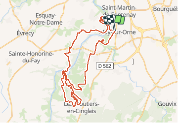

Length
42 km

Max alt
145 m

Uphill gradient
607 m
Km-Effort
50 km

Min alt
6 m

Downhill gradient
603 m
Boucle
No
Creation date :
2016-04-23 00:00:00.0
Updated on :
2016-04-23 00:00:00.0
3h03
Difficulty : Medium

FREE GPS app for hiking
 SityTrail
IGN / Geographical institutes
SityTrail Plus
The world is yours!
About
Trail Mountain bike of 42 km to be discovered at Normandy, Calvados, May-sur-Orne. This trail is proposed by albers.
Positioning
Country:
France
Region :
Normandy
Department/Province :
Calvados
Municipality :
May-sur-Orne
Location:
Unknown
Start:(Dec)
Start:(UTM)
691324 ; 5442076 (30U) N.
Comments