


trcbr en bout

brandy
User
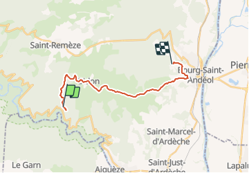

Length
17.9 km

Max alt
358 m

Uphill gradient
179 m
Km-Effort
21 km

Min alt
108 m

Downhill gradient
298 m
Boucle
No
Creation date :
2021-12-16 15:34:40.72
Updated on :
2021-12-16 17:36:50.612
2h01
Difficulty : Very difficult

FREE GPS app for hiking
 SityTrail
IGN / Geographical institutes
SityTrail Plus
The world is yours!
About
Trail Walking of 17.9 km to be discovered at Auvergne-Rhône-Alpes, Ardèche, Saint-Remèze. This trail is proposed by brandy.
Positioning
Country:
France
Region :
Auvergne-Rhône-Alpes
Department/Province :
Ardèche
Municipality :
Saint-Remèze
Location:
Unknown
Start:(Dec)
Start:(UTM)
620329 ; 4911636 (31T) N.
Comments