


Col de u Rousset

raygautier
User
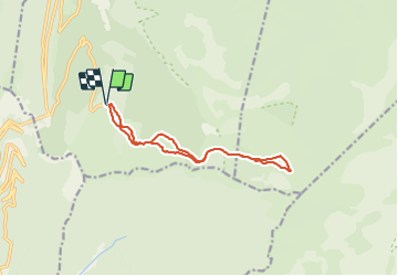

Length
12 km

Max alt
1673 m

Uphill gradient
493 m
Km-Effort
18.6 km

Min alt
1401 m

Downhill gradient
493 m
Boucle
Yes
Creation date :
2021-12-16 08:24:02.0
Updated on :
2021-12-16 18:17:01.218
3h57
Difficulty : Difficult

FREE GPS app for hiking
 SityTrail
IGN / Geographical institutes
SityTrail Plus
The world is yours!
About
Trail Walking of 12 km to be discovered at Auvergne-Rhône-Alpes, Drôme, Saint-Agnan-en-Vercors. This trail is proposed by raygautier.
Positioning
Country:
France
Region :
Auvergne-Rhône-Alpes
Department/Province :
Drôme
Municipality :
Saint-Agnan-en-Vercors
Location:
Unknown
Start:(Dec)
Start:(UTM)
691580 ; 4968315 (31T) N.
Comments