


20211218

fredodlageo
User
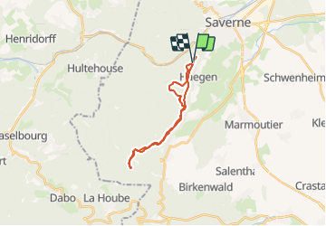

Length
19.3 km

Max alt
531 m

Uphill gradient
524 m
Km-Effort
26 km

Min alt
384 m

Downhill gradient
526 m
Boucle
Yes
Creation date :
2021-12-18 13:47:39.0
Updated on :
2021-12-18 15:25:57.14
1h37
Difficulty : Medium

FREE GPS app for hiking
 SityTrail
IGN / Geographical institutes
SityTrail Plus
The world is yours!
About
Trail Mountain bike of 19.3 km to be discovered at Grand Est, Bas-Rhin, Haegen. This trail is proposed by fredodlageo.
Description
Sortie vtt
Positioning
Country:
France
Region :
Grand Est
Department/Province :
Bas-Rhin
Municipality :
Haegen
Location:
Unknown
Start:(Dec)
Start:(UTM)
377594 ; 5397825 (32U) N.
Comments