


Champion bretonnes

lucmarescot
User
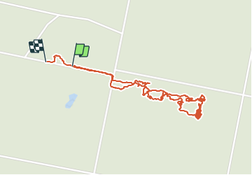

Length
2.9 km

Max alt
57 m

Uphill gradient
14 m
Km-Effort
3.1 km

Min alt
49 m

Downhill gradient
13 m
Boucle
Yes
Creation date :
2021-12-17 07:51:28.0
Updated on :
2021-12-18 19:21:19.679
2h40
Difficulty : Unknown

FREE GPS app for hiking
 SityTrail
IGN / Geographical institutes
SityTrail Plus
The world is yours!
About
Trail Climbing of 2.9 km to be discovered at Normandy, Seine-Maritime, Arelaune-en-Seine. This trail is proposed by lucmarescot.
Description
B
Positioning
Country:
France
Region :
Normandy
Department/Province :
Seine-Maritime
Municipality :
Arelaune-en-Seine
Location:
La Mailleraye-sur-Seine
Start:(Dec)
Start:(UTM)
334480 ; 5479752 (31U) N.
Comments