


St Etienne de Fontbellon- Gaudes

Linerou
User
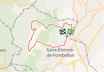

Length
7.8 km

Max alt
332 m

Uphill gradient
234 m
Km-Effort
10.9 km

Min alt
212 m

Downhill gradient
237 m
Boucle
Yes
Creation date :
2021-12-19 17:53:03.259
Updated on :
2021-12-19 17:53:49.714
2h28
Difficulty : Easy

FREE GPS app for hiking
 SityTrail
IGN / Geographical institutes
SityTrail Plus
The world is yours!
About
Trail On foot of 7.8 km to be discovered at Auvergne-Rhône-Alpes, Ardèche, Saint-Étienne-de-Fontbellon. This trail is proposed by Linerou.
Positioning
Country:
France
Region :
Auvergne-Rhône-Alpes
Department/Province :
Ardèche
Municipality :
Saint-Étienne-de-Fontbellon
Location:
Unknown
Start:(Dec)
Start:(UTM)
609661 ; 4939781 (31T) N.
Comments