


calanques candelle

sterdyniak
User
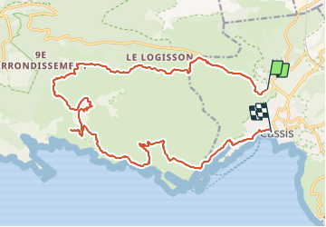

Length
25 km

Max alt
536 m

Uphill gradient
1015 m
Km-Effort
39 km

Min alt
4 m

Downhill gradient
1125 m
Boucle
No
Creation date :
2021-12-21 08:08:08.606
Updated on :
2021-12-22 13:30:41.331
7h31
Difficulty : Medium

FREE GPS app for hiking
 SityTrail
IGN / Geographical institutes
SityTrail Plus
The world is yours!
About
Trail Walking of 25 km to be discovered at Provence-Alpes-Côte d'Azur, Bouches-du-Rhône, Cassis. This trail is proposed by sterdyniak.
Description
rando escarpée
Positioning
Country:
France
Region :
Provence-Alpes-Côte d'Azur
Department/Province :
Bouches-du-Rhône
Municipality :
Cassis
Location:
Unknown
Start:(Dec)
Start:(UTM)
705983 ; 4789016 (31T) N.
Comments