


Chaudfontaine Sources - Ninane

Delhezpy
User
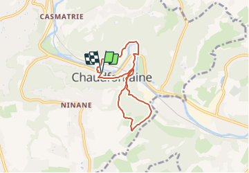

Length
5.4 km

Max alt
213 m

Uphill gradient
212 m
Km-Effort
8.2 km

Min alt
75 m

Downhill gradient
211 m
Boucle
Yes
Creation date :
2021-12-23 08:54:03.347
Updated on :
2021-12-23 08:54:54.155
1h52
Difficulty : Medium

FREE GPS app for hiking
 SityTrail
IGN / Geographical institutes
SityTrail Plus
The world is yours!
About
Trail Walking of 5.4 km to be discovered at Wallonia, Liège, Chaudfontaine. This trail is proposed by Delhezpy.
Positioning
Country:
Belgium
Region :
Wallonia
Department/Province :
Liège
Municipality :
Chaudfontaine
Location:
Unknown
Start:(Dec)
Start:(UTM)
687205 ; 5607047 (31U) N.
Comments