Trail Walking Presles - 2021-12-23_15h06m57_ignrando_ios_export - Photo

2021-12-23_15h06m57_ignrando_ios_export

© OpenStreetMap contributors
Length
Length
15.8 km
Max alt
Max alt
213 m
Uphill gradient
Uphill gradient
391 m
Km-Effort
Km-Effort  
21 km
Min alt
Min alt
48 m
Downhill gradient
Downhill gradient
389 m
Boucle
Boucle
Yes
Creation date :
2021-12-23 14:06:57.843
Updated on :
2023-01-11 10:32:20.087

(0 Reviews)

Walking
Walking
4h46
Difficulty : Very difficult

Scan this QR Code to open this trail in the SityTrail application

FREE GPS app for hiking

Logo SityTrail SityTrail

IGN / Geographical institutes

Download SityTrail from the App Store Download SityTrail from Google Play

Logo SityTrail SityTrail Plus

The world is yours!

Download SityTrail from the App Store Download SityTrail from Google Play Download SityTrail on Huawei AppGallery

About

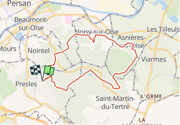
Trail Walking of 15.8 km to be discovered at Ile-de-France, Val-d'Oise, Presles. This trail is proposed by philberard95.

Description

Randonnée de 17 km et de 483 m de dénivelé. Étang bleu et petit étang. Pierre Turquaise. Noisy sur Oise. Asnières  sur Oise possibilité de hors sac au café tabac sur la place de l'église au milieu du parcours.

Elevation profile

Positioning

Country:
France
Region :
Ile-de-France
Department/Province :
Val-d'Oise
Municipality :
Presles
Location:
Unknown
Start:(Dec)
Start:(UTM)
448380 ; 5440550 (31U) N.


Close
My subscriptions