


CeYrat - tour de montrognon 8,3 km

jeanic63
User
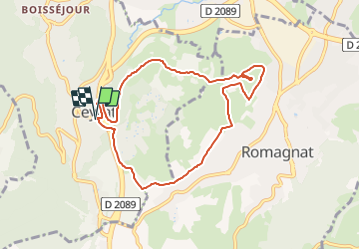

Length
8 km

Max alt
576 m

Uphill gradient
166 m
Km-Effort
10.2 km

Min alt
481 m

Downhill gradient
166 m
Boucle
Yes
Creation date :
2021-12-23 17:48:21.539
Updated on :
2025-07-02 08:20:44.0
2h19
Difficulty : Easy

FREE GPS app for hiking
 SityTrail
IGN / Geographical institutes
SityTrail Plus
The world is yours!
About
Trail On foot of 8 km to be discovered at Auvergne-Rhône-Alpes, Puy-de-Dôme, Ceyrat. This trail is proposed by jeanic63.
Description
départ salle polyvalente des sports
Positioning
Country:
France
Region :
Auvergne-Rhône-Alpes
Department/Province :
Puy-de-Dôme
Municipality :
Ceyrat
Location:
Unknown
Start:(Dec)
Start:(UTM)
505320 ; 5064507 (31T) N.
Comments