


hat

Jean Marc
User
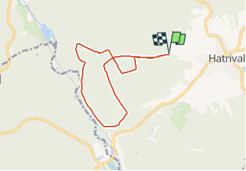

Length
6.8 km

Max alt
462 m

Uphill gradient
194 m
Km-Effort
9.4 km

Min alt
355 m

Downhill gradient
195 m
Boucle
Yes
Creation date :
2021-12-26 09:02:13.795
Updated on :
2021-12-26 10:26:42.63
1h24
Difficulty : Medium

FREE GPS app for hiking
 SityTrail
IGN / Geographical institutes
SityTrail Plus
The world is yours!
About
Trail Walking of 6.8 km to be discovered at Wallonia, Luxembourg, Saint-Hubert. This trail is proposed by Jean Marc .
Positioning
Country:
Belgium
Region :
Wallonia
Department/Province :
Luxembourg
Municipality :
Saint-Hubert
Location:
Unknown
Start:(Dec)
Start:(UTM)
667209 ; 5541898 (31U) N.
Comments