


2021-12-27_11h19m16_gpx-trace

Linerou
User
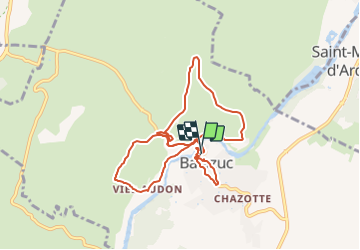

Length
9.7 km

Max alt
233 m

Uphill gradient
341 m
Km-Effort
14.3 km

Min alt
129 m

Downhill gradient
345 m
Boucle
Yes
Creation date :
2021-12-27 10:19:16.781
Updated on :
2022-01-02 18:25:33.38
3h14
Difficulty : Medium

FREE GPS app for hiking
 SityTrail
IGN / Geographical institutes
SityTrail Plus
The world is yours!
About
Trail Walking of 9.7 km to be discovered at Auvergne-Rhône-Alpes, Ardèche, Balazuc. This trail is proposed by Linerou.
Positioning
Country:
France
Region :
Auvergne-Rhône-Alpes
Department/Province :
Ardèche
Municipality :
Balazuc
Location:
Unknown
Start:(Dec)
Start:(UTM)
609045 ; 4929469 (31T) N.
Comments