


Bologne 2

PhilippeC54
User

Length
24 km

Max alt
356 m

Uphill gradient
396 m
Km-Effort
30 km

Min alt
221 m

Downhill gradient
396 m
Boucle
Yes
Creation date :
2021-12-28 13:30:31.625
Updated on :
2021-12-28 15:29:39.923
1h48
Difficulty : Medium

FREE GPS app for hiking
 SityTrail
IGN / Geographical institutes
SityTrail Plus
The world is yours!
About
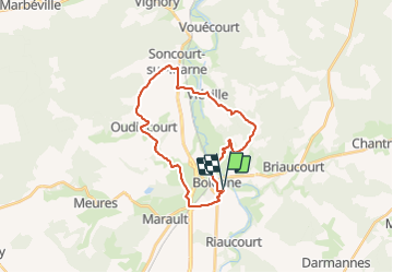
Trail Mountain bike of 24 km to be discovered at Grand Est, Haute-Marne, Bologne. This trail is proposed by PhilippeC54.
Positioning
Country:
France
Region :
Grand Est
Department/Province :
Haute-Marne
Municipality :
Bologne
Location:
Bologne
Start:(Dec)
Start:(UTM)
659416 ; 5340743 (31U) N.
Comments