


2021-12-29_18h58m39_utgtrack-5853

inesmyt
User

Length
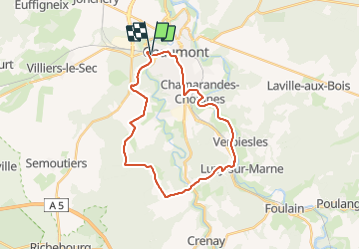
25 km

Max alt
382 m

Uphill gradient
372 m
Km-Effort
30 km

Min alt
261 m

Downhill gradient
371 m
Boucle
Yes
Creation date :
2021-12-29 17:58:40.734
Updated on :
2021-12-29 18:11:52.042
2h06
Difficulty : Medium

FREE GPS app for hiking
 SityTrail
IGN / Geographical institutes
SityTrail Plus
The world is yours!
About
Trail Mountain bike of 25 km to be discovered at Grand Est, Haute-Marne, Chaumont. This trail is proposed by inesmyt.
Positioning
Country:
France
Region :
Grand Est
Department/Province :
Haute-Marne
Municipality :
Chaumont
Location:
Unknown
Start:(Dec)
Start:(UTM)
658038 ; 5330683 (31U) N.
Comments