


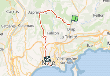
Cantaron-Nice

coriace
User

Length
21 km

Max alt
694 m

Uphill gradient
928 m
Km-Effort
34 km

Min alt
9 m

Downhill gradient
1021 m
Boucle
No
Creation date :
2021-12-30 11:28:48.848
Updated on :
2021-12-30 17:00:42.548
5h25
Difficulty : Difficult

FREE GPS app for hiking
 SityTrail
IGN / Geographical institutes
SityTrail Plus
The world is yours!
About
Trail Walking of 21 km to be discovered at Provence-Alpes-Côte d'Azur, Maritime Alps, Cantaron. This trail is proposed by coriace.
Description
Départ de Nice vers Cantaron en Ubert
Retour sur vieux Nice centre à pied.
Positioning
Country:
France
Region :
Provence-Alpes-Côte d'Azur
Department/Province :
Maritime Alps
Municipality :
Cantaron
Location:
Unknown
Start:(Dec)
Start:(UTM)
364651 ; 4846765 (32T) N.
Comments