


richardmenil-6km

ZAMBAUX
User
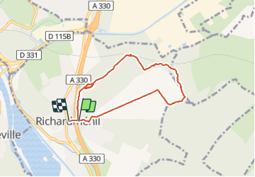

Length
6.4 km

Max alt
283 m

Uphill gradient
78 m
Km-Effort
7.4 km

Min alt
255 m

Downhill gradient
80 m
Boucle
Yes
Creation date :
2021-12-31 13:04:47.071
Updated on :
2021-12-31 14:45:28.278
1h40
Difficulty : Medium

FREE GPS app for hiking
 SityTrail
IGN / Geographical institutes
SityTrail Plus
The world is yours!
About
Trail Walking of 6.4 km to be discovered at Grand Est, Meurthe-et-Moselle, Richardménil. This trail is proposed by ZAMBAUX.
Positioning
Country:
France
Region :
Grand Est
Department/Province :
Meurthe-et-Moselle
Municipality :
Richardménil
Location:
Unknown
Start:(Dec)
Start:(UTM)
291513 ; 5386221 (32U) N.
Comments