


avec les copains de Minouche

CDSM 55
User
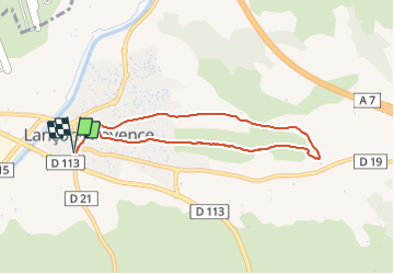

Length
7.3 km

Max alt
131 m

Uphill gradient
116 m
Km-Effort
8.9 km

Min alt
77 m

Downhill gradient
114 m
Boucle
Yes
Creation date :
2021-12-31 12:56:17.187
Updated on :
2021-12-31 15:35:42.424
2h13
Difficulty : Easy

FREE GPS app for hiking
 SityTrail
IGN / Geographical institutes
SityTrail Plus
The world is yours!
About
Trail Walking of 7.3 km to be discovered at Provence-Alpes-Côte d'Azur, Bouches-du-Rhône, Lançon-Provence. This trail is proposed by CDSM 55.
Description
belle première partie sur la colline
Positioning
Country:
France
Region :
Provence-Alpes-Côte d'Azur
Department/Province :
Bouches-du-Rhône
Municipality :
Lançon-Provence
Location:
Unknown
Start:(Dec)
Start:(UTM)
671426 ; 4828445 (31T) N.
Comments