


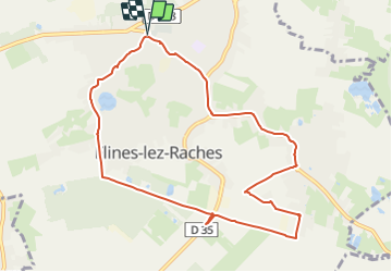
circuit de Flines les Râches par le pont aux Vaches

BrassensJC
User

Length
8.9 km

Max alt
27 m

Uphill gradient
31 m
Km-Effort
9.4 km

Min alt
16 m

Downhill gradient
31 m
Boucle
Yes
Creation date :
2022-01-02 11:54:24.466
Updated on :
2022-01-02 11:55:12.884
2h07
Difficulty : Medium

FREE GPS app for hiking
 SityTrail
IGN / Geographical institutes
SityTrail Plus
The world is yours!
About
Trail Walking of 8.9 km to be discovered at Hauts-de-France, Nord, Flines-lez-Raches. This trail is proposed by BrassensJC.
Positioning
Country:
France
Region :
Hauts-de-France
Department/Province :
Nord
Municipality :
Flines-lez-Raches
Location:
Unknown
Start:(Dec)
Start:(UTM)
512682 ; 5586337 (31U) N.
Comments