Challes-G1

Valmeinier
User
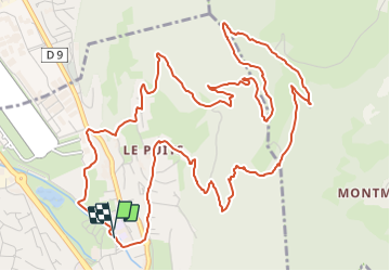

Length
8.1 km

Max alt
748 m

Uphill gradient
451 m
Km-Effort
14.1 km

Min alt
291 m

Downhill gradient
449 m
Boucle
Yes
Creation date :
2022-01-03 08:21:47.218
Updated on :
2022-01-03 08:21:47.218
--
Difficulty : Unknown

FREE GPS app for hiking
 SityTrail
IGN / Geographical institutes
SityTrail Plus
The world is yours!
About
Trail Walking of 8.1 km to be discovered at Auvergne-Rhône-Alpes, Savoy, Challes-les-Eaux. This trail is proposed by Valmeinier.
Positioning
Country:
France
Region :
Auvergne-Rhône-Alpes
Department/Province :
Savoy
Municipality :
Challes-les-Eaux
Location:
Unknown
Start:(Dec)
Start:(UTM)
732991 ; 5048662 (31T) N.
Comments