


Les randonnées du Nico

CDSM 55
User

Length
7.5 km

Max alt
403 m

Uphill gradient
124 m
Km-Effort
9.1 km

Min alt
304 m

Downhill gradient
127 m
Boucle
Yes
Creation date :
2022-01-03 13:23:01.412
Updated on :
2022-01-03 14:57:08.16
1h31
Difficulty : Easy

FREE GPS app for hiking
 SityTrail
IGN / Geographical institutes
SityTrail Plus
The world is yours!
About
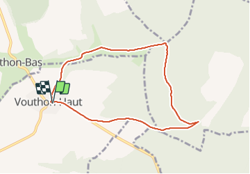
Trail Walking of 7.5 km to be discovered at Grand Est, Meuse, Vouthon-Haut. This trail is proposed by CDSM 55.
Description
une visite à la ferme photo voltaïque
Positioning
Country:
France
Region :
Grand Est
Department/Province :
Meuse
Municipality :
Vouthon-Haut
Location:
Unknown
Start:(Dec)
Start:(UTM)
693506 ; 5372556 (31U) N.
Comments