


Puy Chopine et Puy de Clermont

jpcccb
User
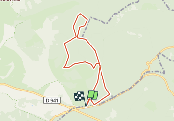

Length
7.9 km

Max alt
1123 m

Uphill gradient
221 m
Km-Effort
10.8 km

Min alt
954 m

Downhill gradient
220 m
Boucle
Yes
Creation date :
2022-01-04 14:48:25.462
Updated on :
2022-01-04 14:49:15.823
2h27
Difficulty : Medium

FREE GPS app for hiking
 SityTrail
IGN / Geographical institutes
SityTrail Plus
The world is yours!
About
Trail Walking of 7.9 km to be discovered at Auvergne-Rhône-Alpes, Puy-de-Dôme, Saint-Ours. This trail is proposed by jpcccb.
Positioning
Country:
France
Region :
Auvergne-Rhône-Alpes
Department/Province :
Puy-de-Dôme
Municipality :
Saint-Ours
Location:
Unknown
Start:(Dec)
Start:(UTM)
496739 ; 5073429 (31T) N.
Comments