


comprégnac

pipette12
User
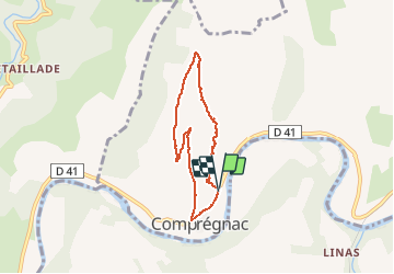

Length
6 km

Max alt
626 m

Uphill gradient
282 m
Km-Effort
9.8 km

Min alt
344 m

Downhill gradient
287 m
Boucle
Yes
Creation date :
2014-12-10 00:00:00.0
Updated on :
2014-12-10 00:00:00.0
2h03
Difficulty : Easy

FREE GPS app for hiking
 SityTrail
IGN / Geographical institutes
SityTrail Plus
The world is yours!
About
Trail Walking of 6 km to be discovered at Occitania, Aveyron, Comprégnac. This trail is proposed by pipette12.
Description
départ du village
Positioning
Country:
France
Region :
Occitania
Department/Province :
Aveyron
Municipality :
Comprégnac
Location:
Unknown
Start:(Dec)
Start:(UTM)
497138 ; 4881559 (31T) N.
Comments