


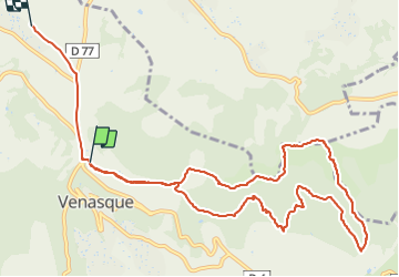
Les hauteurs de Venasque

micheldutilleul
User

Length
13.2 km

Max alt
417 m

Uphill gradient
359 m
Km-Effort
18 km

Min alt
165 m

Downhill gradient
374 m
Boucle
No
Creation date :
2022-01-06 13:34:30.069
Updated on :
2022-01-06 16:43:14.519
2h45
Difficulty : Medium

FREE GPS app for hiking
 SityTrail
IGN / Geographical institutes
SityTrail Plus
The world is yours!
About
Trail Walking of 13.2 km to be discovered at Provence-Alpes-Côte d'Azur, Vaucluse, Venasque. This trail is proposed by micheldutilleul.
Description
Magnifique balade, mais il faut être un peu sportif.
Vue sur le mont Ventoux, passage dans la Nesque.
Positioning
Country:
France
Region :
Provence-Alpes-Côte d'Azur
Department/Province :
Vaucluse
Municipality :
Venasque
Location:
Unknown
Start:(Dec)
Start:(UTM)
672025 ; 4874184 (31T) N.
Comments