


Col du Bougnon - Peigros

LtZIP
User
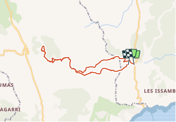

Length
15.9 km

Max alt
524 m

Uphill gradient
625 m
Km-Effort
24 km

Min alt
122 m

Downhill gradient
694 m
Boucle
No
Creation date :
2022-01-06 08:05:15.809
Updated on :
2022-01-10 14:08:30.025
4h04
Difficulty : Very difficult

FREE GPS app for hiking
 SityTrail
IGN / Geographical institutes
SityTrail Plus
The world is yours!
About
Trail Walking of 15.9 km to be discovered at Provence-Alpes-Côte d'Azur, Var, Roquebrune-sur-Argens. This trail is proposed by LtZIP.
Description
IBP
Orange 65
Photos


Positioning
Country:
France
Region :
Provence-Alpes-Côte d'Azur
Department/Province :
Var
Municipality :
Roquebrune-sur-Argens
Location:
Unknown
Start:(Dec)
Start:(UTM)
311112 ; 4803838 (32T) N.
Comments
merci d'avoir partager cette rando elle est vraiment geniale