


maison forest. 06/01/22
© OpenStreetMap contributors


2h11
Difficulty : Medium


Length
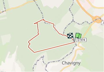
6.3 km
Max alt
417 m
Uphill gradient
105 m
Km-Effort
7.7 km
Min alt
374 m
Downhill gradient
103 m
Boucle
Yes
Creation date :
2022-01-06 13:14:55.928
Updated on :
2022-01-07 04:02:35.954
2h11
Difficulty : Medium
FREE GPS app for hiking
 SityTrail
IGN / Geographical institutes
SityTrail Plus
The world is yours!
About
Trail Walking of 6.3 km to be discovered at Grand Est, Meurthe-et-Moselle, Chavigny. This trail is proposed by jerome-dupont@laposte.net.
Description
chemins sentiers boueux. motos. quads
Positioning
Country:
France
Region :
Grand Est
Department/Province :
Meurthe-et-Moselle
Municipality :
Chavigny
Location:
Unknown
Start:(Dec)
Start:(UTM)
288327 ; 5391152 (32U) N.
Comments