


Ludres

topnature !
User
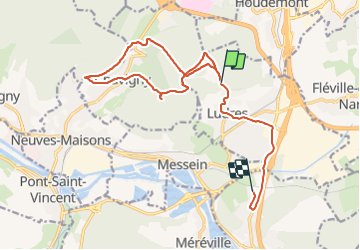

Length
15.7 km

Max alt
422 m

Uphill gradient
227 m
Km-Effort
19.3 km

Min alt
239 m

Downhill gradient
388 m
Boucle
No
Creation date :
2022-01-07 12:35:07.0
Updated on :
2022-01-07 16:28:51.544
3h50
Difficulty : Medium

FREE GPS app for hiking
 SityTrail
IGN / Geographical institutes
SityTrail Plus
The world is yours!
About
Trail Walking of 15.7 km to be discovered at Grand Est, Meurthe-et-Moselle, Ludres. This trail is proposed by topnature !.
Description
. Du plateau aux sources
Positioning
Country:
France
Region :
Grand Est
Department/Province :
Meurthe-et-Moselle
Municipality :
Ludres
Location:
Unknown
Start:(Dec)
Start:(UTM)
290670 ; 5390071 (32U) N.
Comments