


les randos du Nico 4

CDSM 55
User

Length
9.3 km

Max alt
408 m

Uphill gradient
180 m
Km-Effort
11.7 km

Min alt
304 m

Downhill gradient
183 m
Boucle
Yes
Creation date :
2022-01-11 12:33:55.457
Updated on :
2022-01-11 14:32:58.124
1h50
Difficulty : Medium

FREE GPS app for hiking
 SityTrail
IGN / Geographical institutes
SityTrail Plus
The world is yours!
About
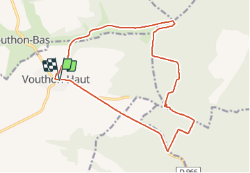
Trail Walking of 9.3 km to be discovered at Grand Est, Meuse, Vouthon-Haut. This trail is proposed by CDSM 55.
Description
encore en repairage pour Vtt
Positioning
Country:
France
Region :
Grand Est
Department/Province :
Meuse
Municipality :
Vouthon-Haut
Location:
Unknown
Start:(Dec)
Start:(UTM)
693496 ; 5372552 (31U) N.
Comments