


bullig

Nila81
User
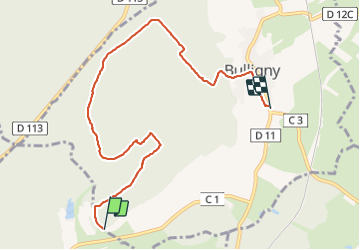

Length
7.4 km

Max alt
420 m

Uphill gradient
143 m
Km-Effort
9.5 km

Min alt
286 m

Downhill gradient
201 m
Boucle
No
Creation date :
2022-01-11 13:42:38.192
Updated on :
2022-01-11 15:48:57.684
2h05
Difficulty : Medium

FREE GPS app for hiking
 SityTrail
IGN / Geographical institutes
SityTrail Plus
The world is yours!
About
Trail Walking of 7.4 km to be discovered at Grand Est, Meurthe-et-Moselle, Bulligny. This trail is proposed by Nila81.
Description
tyu
Positioning
Country:
France
Region :
Grand Est
Department/Province :
Meurthe-et-Moselle
Municipality :
Bulligny
Location:
Unknown
Start:(Dec)
Start:(UTM)
708516 ; 5382117 (31U) N.
Comments