


2021-08-19 11-42-50-MNT

jeanic63
User
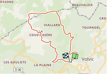

Length
9.1 km

Max alt
768 m

Uphill gradient
247 m
Km-Effort
12.3 km

Min alt
573 m

Downhill gradient
246 m
Boucle
Yes
Creation date :
2022-01-12 13:09:34.141
Updated on :
2022-01-12 13:13:46.257
2h48
Difficulty : Easy

FREE GPS app for hiking
 SityTrail
IGN / Geographical institutes
SityTrail Plus
The world is yours!
About
Trail On foot of 9.1 km to be discovered at Auvergne-Rhône-Alpes, Puy-de-Dôme, Volvic. This trail is proposed by jeanic63.
Description
départ parking des sources de volvic


Positioning
Country:
France
Region :
Auvergne-Rhône-Alpes
Department/Province :
Puy-de-Dôme
Municipality :
Volvic
Location:
Unknown
Start:(Dec)
Start:(UTM)
502168 ; 5079720 (31T) N.
Comments