


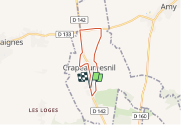
crapeaumesnil

NESTOR2714
User

Length
4.3 km

Max alt
97 m

Uphill gradient
17 m
Km-Effort
4.5 km

Min alt
82 m

Downhill gradient
19 m
Boucle
Yes
Creation date :
2022-01-12 13:13:52.665
Updated on :
2022-01-12 13:14:46.35
1h01
Difficulty : Easy

FREE GPS app for hiking
 SityTrail
IGN / Geographical institutes
SityTrail Plus
The world is yours!
About
Trail Walking of 4.3 km to be discovered at Hauts-de-France, Oise, Crapeaumesnil. This trail is proposed by NESTOR2714.
Positioning
Country:
France
Region :
Hauts-de-France
Department/Province :
Oise
Municipality :
Crapeaumesnil
Location:
Unknown
Start:(Dec)
Start:(UTM)
485430 ; 5498269 (31U) N.
Comments