


12/01/22 clairlieu
© OpenStreetMap contributors


3h23
Difficulty : Difficult


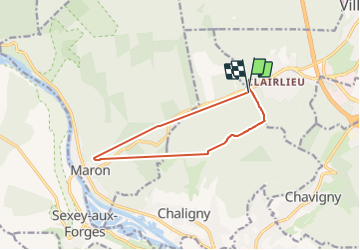
Length
9.9 km
Max alt
406 m
Uphill gradient
213 m
Km-Effort
12.7 km
Min alt
267 m
Downhill gradient
208 m
Boucle
Yes
Creation date :
2022-01-12 12:30:35.938
Updated on :
2022-01-12 23:40:52.895
3h23
Difficulty : Difficult
FREE GPS app for hiking
 SityTrail
IGN / Geographical institutes
SityTrail Plus
The world is yours!
About
Trail Walking of 9.9 km to be discovered at Grand Est, Meurthe-et-Moselle, Chaligny. This trail is proposed by jerome-dupont@laposte.net.
Description
marche rapide ,14 km
Positioning
Country:
France
Region :
Grand Est
Department/Province :
Meurthe-et-Moselle
Municipality :
Chaligny
Location:
Unknown
Start:(Dec)
Start:(UTM)
286637 ; 5392994 (32U) N.
Comments