


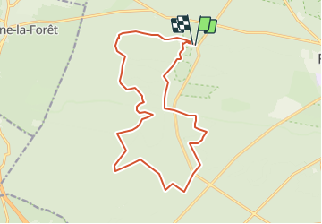
Franchard

c.chehere
User

Length
17 km

Max alt
147 m

Uphill gradient
183 m
Km-Effort
19.5 km

Min alt
89 m

Downhill gradient
182 m
Boucle
Yes
Creation date :
2022-01-14 07:11:26.366
Updated on :
2022-01-14 07:12:24.877
4h25
Difficulty : Very difficult

FREE GPS app for hiking
 SityTrail
IGN / Geographical institutes
SityTrail Plus
The world is yours!
About
Trail Walking of 17 km to be discovered at Ile-de-France, Seine-et-Marne, Fontainebleau. This trail is proposed by c.chehere.
Description
Depuis l'ermitage de Franchard
Positioning
Country:
France
Region :
Ile-de-France
Department/Province :
Seine-et-Marne
Municipality :
Fontainebleau
Location:
Unknown
Start:(Dec)
Start:(UTM)
473144 ; 5361752 (31U) N.
Comments