


ARDIALLE BOUCLE

CANON2
User
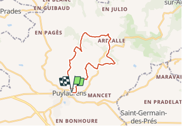

Length
12.8 km

Max alt
345 m

Uphill gradient
308 m
Km-Effort
16.9 km

Min alt
206 m

Downhill gradient
306 m
Boucle
Yes
Creation date :
2022-01-17 08:02:54.113
Updated on :
2022-01-17 08:03:43.335
3h49
Difficulty : Easy

FREE GPS app for hiking
 SityTrail
IGN / Geographical institutes
SityTrail Plus
The world is yours!
About
Trail On foot of 12.8 km to be discovered at Occitania, Tarn, Puylaurens. This trail is proposed by CANON2.
Positioning
Country:
France
Region :
Occitania
Department/Province :
Tarn
Municipality :
Puylaurens
Location:
Unknown
Start:(Dec)
Start:(UTM)
420480 ; 4824896 (31T) N.
Comments