


track

CANON2
User
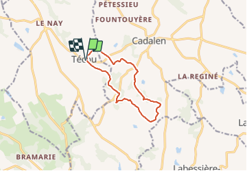

Length
10.5 km

Max alt
324 m

Uphill gradient
228 m
Km-Effort
13.5 km

Min alt
208 m

Downhill gradient
227 m
Boucle
Yes
Creation date :
2022-01-18 07:42:25.121
Updated on :
2022-01-18 07:43:15.685
3h04
Difficulty : Easy

FREE GPS app for hiking
 SityTrail
IGN / Geographical institutes
SityTrail Plus
The world is yours!
About
Trail On foot of 10.5 km to be discovered at Occitania, Tarn, Técou. This trail is proposed by CANON2.
Positioning
Country:
France
Region :
Occitania
Department/Province :
Tarn
Municipality :
Técou
Location:
Unknown
Start:(Dec)
Start:(UTM)
415596 ; 4854947 (31T) N.
Comments