


track

CANON2
User
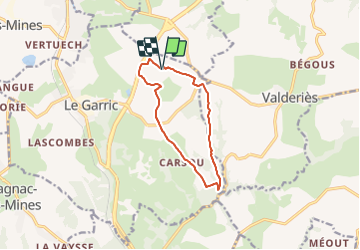

Length
10.3 km

Max alt
356 m

Uphill gradient
186 m
Km-Effort
12.8 km

Min alt
236 m

Downhill gradient
182 m
Boucle
Yes
Creation date :
2022-01-18 07:53:36.261
Updated on :
2022-01-18 07:54:18.269
2h54
Difficulty : Easy

FREE GPS app for hiking
 SityTrail
IGN / Geographical institutes
SityTrail Plus
The world is yours!
About
Trail On foot of 10.3 km to be discovered at Occitania, Tarn, Le Garric. This trail is proposed by CANON2.
Positioning
Country:
France
Region :
Occitania
Department/Province :
Tarn
Municipality :
Le Garric
Location:
Unknown
Start:(Dec)
Start:(UTM)
435081 ; 4874306 (31T) N.
Comments