


randogps11-240

CANON2
User
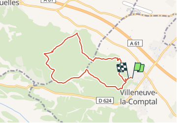

Length
7.9 km

Max alt
298 m

Uphill gradient
204 m
Km-Effort
10.5 km

Min alt
200 m

Downhill gradient
188 m
Boucle
Yes
Creation date :
2022-01-18 08:09:46.518
Updated on :
2022-01-18 08:10:35.983
2h23
Difficulty : Easy

FREE GPS app for hiking
 SityTrail
IGN / Geographical institutes
SityTrail Plus
The world is yours!
About
Trail On foot of 7.9 km to be discovered at Occitania, Aude, Villeneuve-la-Comptal. This trail is proposed by CANON2.
Positioning
Country:
France
Region :
Occitania
Department/Province :
Aude
Municipality :
Villeneuve-la-Comptal
Location:
Unknown
Start:(Dec)
Start:(UTM)
412387 ; 4793894 (31T) N.
Comments