


randogps11-370

CANON2
User
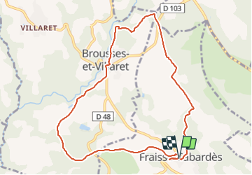

Length
10.5 km

Max alt
480 m

Uphill gradient
215 m
Km-Effort
13.4 km

Min alt
295 m

Downhill gradient
215 m
Boucle
Yes
Creation date :
2022-01-18 08:27:34.971
Updated on :
2022-01-18 08:28:22.92
3h02
Difficulty : Easy

FREE GPS app for hiking
 SityTrail
IGN / Geographical institutes
SityTrail Plus
The world is yours!
About
Trail On foot of 10.5 km to be discovered at Occitania, Aude, Fraisse-Cabardès. This trail is proposed by CANON2.


Positioning
Country:
France
Region :
Occitania
Department/Province :
Aude
Municipality :
Fraisse-Cabardès
Location:
Unknown
Start:(Dec)
Start:(UTM)
440930 ; 4797214 (31T) N.
Comments