


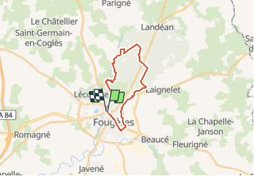
Parking du Nançon-Ecartelée-Base Chênedet 19km JY

COGLAIS3
User

Length
19.3 km

Max alt
193 m

Uphill gradient
261 m
Km-Effort
23 km

Min alt
80 m

Downhill gradient
267 m
Boucle
Yes
Creation date :
2022-01-18 07:13:04.809
Updated on :
2022-01-18 19:43:14.629
3h31
Difficulty : Easy

FREE GPS app for hiking
 SityTrail
IGN / Geographical institutes
SityTrail Plus
The world is yours!
About
Trail Nordic walking of 19.3 km to be discovered at Brittany, Ille-et-Vilaine, Fougères. This trail is proposed by COGLAIS3.
Positioning
Country:
France
Region :
Brittany
Department/Province :
Ille-et-Vilaine
Municipality :
Fougères
Location:
Unknown
Start:(Dec)
Start:(UTM)
633195 ; 5357508 (30U) N.
Comments