


carbonniere

Tommy Eric
User
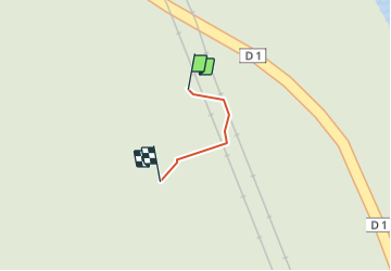

Length
28 m

Max alt
152 m

Uphill gradient
0 m
Km-Effort
28 m

Min alt
152 m

Downhill gradient
0 m
Boucle
No
Creation date :
2022-01-18 13:01:10.954
Updated on :
2022-01-18 13:05:22.158
4m
Difficulty : Easy

FREE GPS app for hiking
 SityTrail
IGN / Geographical institutes
SityTrail Plus
The world is yours!
About
Trail Walking of 28 m to be discovered at Grand Est, Ardennes, Deville. This trail is proposed by Tommy Eric.
Positioning
Country:
France
Region :
Grand Est
Department/Province :
Ardennes
Municipality :
Deville
Location:
Unknown
Start:(Dec)
Start:(UTM)
622964 ; 5525707 (31U) N.
Comments