


Le Tanargue

MarcLEBARON
User

Length
16.4 km

Max alt
250 m

Uphill gradient
433 m
Km-Effort
22 km

Min alt
113 m

Downhill gradient
430 m
Boucle
Yes
Creation date :
2022-01-18 08:46:46.182
Updated on :
2022-01-18 15:27:03.724
4h34
Difficulty : Medium

FREE GPS app for hiking
 SityTrail
IGN / Geographical institutes
SityTrail Plus
The world is yours!
About
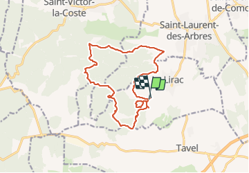
Trail Walking of 16.4 km to be discovered at Occitania, Gard, Lirac. This trail is proposed by MarcLEBARON.
Description
Attention passage délicat entre le km 5 et 6. "Sente" à gibier clapis rocheux saillant sollicitant l'équilibre et les chevilles.
Photos


Positioning
Country:
France
Region :
Occitania
Department/Province :
Gard
Municipality :
Lirac
Location:
Unknown
Start:(Dec)
Start:(UTM)
634535 ; 4876593 (31T) N.
Comments