


Eric philippe

Tommy Eric
User
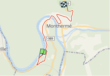

Length
6.1 km

Max alt
251 m

Uphill gradient
230 m
Km-Effort
8.8 km

Min alt
132 m

Downhill gradient
115 m
Boucle
No
Creation date :
2022-01-18 13:23:13.627
Updated on :
2022-01-18 17:14:29.834
2h02
Difficulty : Medium

FREE GPS app for hiking
 SityTrail
IGN / Geographical institutes
SityTrail Plus
The world is yours!
About
Trail Walking of 6.1 km to be discovered at Grand Est, Ardennes, Monthermé. This trail is proposed by Tommy Eric.
Positioning
Country:
France
Region :
Grand Est
Department/Province :
Ardennes
Municipality :
Monthermé
Location:
Unknown
Start:(Dec)
Start:(UTM)
624160 ; 5525876 (31U) N.
Comments