


DIEME

JacouBrijou
User
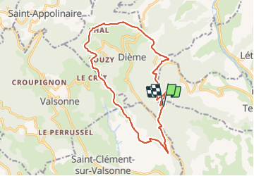

Length
16.6 km

Max alt
810 m

Uphill gradient
584 m
Km-Effort
24 km

Min alt
392 m

Downhill gradient
582 m
Boucle
Yes
Creation date :
2022-01-18 07:43:34.437
Updated on :
2022-01-19 06:34:44.403
5h19
Difficulty : Medium

FREE GPS app for hiking
 SityTrail
IGN / Geographical institutes
SityTrail Plus
The world is yours!
About
Trail Walking of 16.6 km to be discovered at Auvergne-Rhône-Alpes, Rhône, Dième. This trail is proposed by JacouBrijou.
Description
17 km
Magnifique randonnée
Positioning
Country:
France
Region :
Auvergne-Rhône-Alpes
Department/Province :
Rhône
Municipality :
Dième
Location:
Unknown
Start:(Dec)
Start:(UTM)
614833 ; 5088951 (31T) N.
Comments