


20/01/22 clairlieu
© OpenStreetMap contributors


2h08
Difficulty : Medium


Length
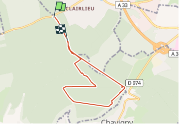
7.3 km
Max alt
406 m
Uphill gradient
123 m
Km-Effort
8.9 km
Min alt
370 m
Downhill gradient
110 m
Boucle
No
Creation date :
2022-01-20 13:29:40.097
Updated on :
2022-01-20 15:39:50.652
2h08
Difficulty : Medium
FREE GPS app for hiking
 SityTrail
IGN / Geographical institutes
SityTrail Plus
The world is yours!
About
Trail Walking of 7.3 km to be discovered at Grand Est, Meurthe-et-Moselle, Chaligny. This trail is proposed by jerome-dupont@laposte.net.
Description
clairlieu-vierge chaligny- val de fer
Positioning
Country:
France
Region :
Grand Est
Department/Province :
Meurthe-et-Moselle
Municipality :
Chaligny
Location:
Unknown
Start:(Dec)
Start:(UTM)
286664 ; 5393001 (32U) N.
Comments