


canirando au départ de Falaen

stephane
User
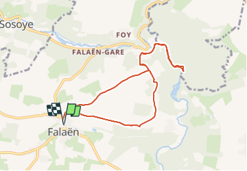

Length
8.2 km

Max alt
230 m

Uphill gradient
180 m
Km-Effort
10.6 km

Min alt
126 m

Downhill gradient
180 m
Boucle
Yes
Creation date :
2022-01-23 09:12:07.637
Updated on :
2022-01-23 11:17:10.832
2h03
Difficulty : Very easy

FREE GPS app for hiking
 SityTrail
IGN / Geographical institutes
SityTrail Plus
The world is yours!
About
Trail Walking of 8.2 km to be discovered at Wallonia, Namur, Onhaye. This trail is proposed by stephane.
Description
Falaen
Positioning
Country:
Belgium
Region :
Wallonia
Department/Province :
Namur
Municipality :
Onhaye
Location:
Unknown
Start:(Dec)
Start:(UTM)
627796 ; 5571212 (31U) N.
Comments