


La balade des Terhills

Ko-Rando
User
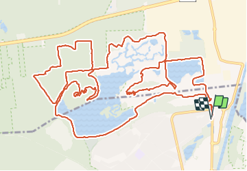

Length
18.8 km

Max alt
113 m

Uphill gradient
297 m
Km-Effort
23 km

Min alt
32 m

Downhill gradient
297 m
Boucle
Yes
Creation date :
2022-01-23 07:44:36.898
Updated on :
2022-01-23 11:44:59.819
3h59
Difficulty : Easy

FREE GPS app for hiking
 SityTrail
IGN / Geographical institutes
SityTrail Plus
The world is yours!
About
Trail Walking of 18.8 km to be discovered at Flanders, Limburg, Maasmechelen. This trail is proposed by Ko-Rando.
Description
Chouette balade. Pas trop sportif et quelques beaux spots 🥾
Photos


Positioning
Country:
Belgium
Region :
Flanders
Department/Province :
Limburg
Municipality :
Maasmechelen
Location:
Eisden
Start:(Dec)
Start:(UTM)
689794 ; 5653174 (31U) N.
Comments