


Dieulefit Comps 12 km

thonyc
User GUIDE
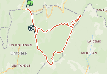

Length
19.2 km

Max alt
1501 m

Uphill gradient
683 m
Km-Effort
28 km

Min alt
1197 m

Downhill gradient
696 m
Boucle
No
Creation date :
2022-01-23 19:41:06.225
Updated on :
2022-01-23 19:50:24.936
4h10
Difficulty : Medium

FREE GPS app for hiking
 SityTrail
IGN / Geographical institutes
SityTrail Plus
The world is yours!
About
Trail Walking of 19.2 km to be discovered at Auvergne-Rhône-Alpes, Drôme, Omblèze. This trail is proposed by thonyc.
Positioning
Country:
France
Region :
Auvergne-Rhône-Alpes
Department/Province :
Drôme
Municipality :
Omblèze
Location:
Unknown
Start:(Dec)
Start:(UTM)
675969 ; 4974179 (31T) N.
Comments