


trace

ochelen
User
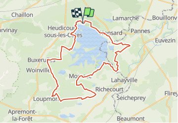

Length
37 km

Max alt
370 m

Uphill gradient
415 m
Km-Effort
43 km

Min alt
214 m

Downhill gradient
405 m
Boucle
Yes
Creation date :
2014-12-10 00:00:00.0
Updated on :
2014-12-10 00:00:00.0
--
Difficulty : Unknown

FREE GPS app for hiking
 SityTrail
IGN / Geographical institutes
SityTrail Plus
The world is yours!
About
Trail Other activity of 37 km to be discovered at Grand Est, Meuse, Heudicourt-sous-les-Côtes. This trail is proposed by ochelen.
Positioning
Country:
France
Region :
Grand Est
Department/Province :
Meuse
Municipality :
Heudicourt-sous-les-Côtes
Location:
Unknown
Start:(Dec)
Start:(UTM)
699421 ; 5424321 (31U) N.
Comments