


les balades du Nico 6

CDSM 55
User

Length
3.8 km

Max alt
430 m

Uphill gradient
68 m
Km-Effort
4.8 km

Min alt
376 m

Downhill gradient
71 m
Boucle
No
Creation date :
2022-01-25 15:44:43.143
Updated on :
2022-01-25 16:23:47.556
38m
Difficulty : Easy

FREE GPS app for hiking
 SityTrail
IGN / Geographical institutes
SityTrail Plus
The world is yours!
About
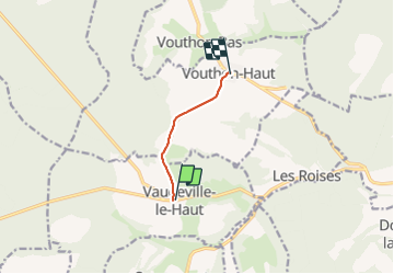
Trail Walking of 3.8 km to be discovered at Grand Est, Meuse, Vaudeville-le-Haut. This trail is proposed by CDSM 55.
Description
de Vaudeville à Vouthon Haut
Positioning
Country:
France
Region :
Grand Est
Department/Province :
Meuse
Municipality :
Vaudeville-le-Haut
Location:
Unknown
Start:(Dec)
Start:(UTM)
692308 ; 5369595 (31U) N.
Comments