


Montgeroult- Boissy l'Aillerie 8.9

Djaie60
User
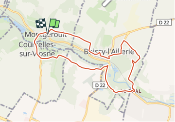

Length
8.9 km

Max alt
83 m

Uphill gradient
147 m
Km-Effort
10.8 km

Min alt
35 m

Downhill gradient
150 m
Boucle
Yes
Creation date :
2022-01-26 09:51:46.204
Updated on :
2022-01-26 09:53:39.171
2h27
Difficulty : Easy

FREE GPS app for hiking
 SityTrail
IGN / Geographical institutes
SityTrail Plus
The world is yours!
About
Trail On foot of 8.9 km to be discovered at Ile-de-France, Val-d'Oise, Montgeroult. This trail is proposed by Djaie60.
Positioning
Country:
France
Region :
Ile-de-France
Department/Province :
Val-d'Oise
Municipality :
Montgeroult
Location:
Unknown
Start:(Dec)
Start:(UTM)
427524 ; 5436923 (31U) N.
Comments