


Chambards 13 km

thonyc
User GUIDE
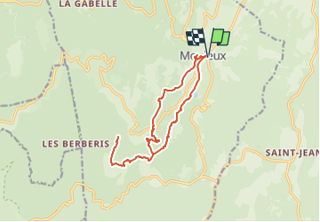

Length
14.9 km

Max alt
869 m

Uphill gradient
663 m
Km-Effort
24 km

Min alt
616 m

Downhill gradient
663 m
Boucle
Yes
Creation date :
2022-01-26 12:38:41.948
Updated on :
2024-05-16 08:23:01.195
5h23
Difficulty : Medium

FREE GPS app for hiking
 SityTrail
IGN / Geographical institutes
SityTrail Plus
The world is yours!
About
Trail Walking of 14.9 km to be discovered at Provence-Alpes-Côte d'Azur, Vaucluse, Monieux. This trail is proposed by thonyc.
Positioning
Country:
France
Region :
Provence-Alpes-Côte d'Azur
Department/Province :
Vaucluse
Municipality :
Monieux
Location:
Unknown
Start:(Dec)
Start:(UTM)
689130 ; 4882061 (31T) N.
Comments